AI and Machine Learning
We work with our clients to deploy AI and machine learning to enhance decision-making through predictive analytics and improving data-driven insights. Our AI specialists deliver the right combination of talent, data infrastructure, and technology platforms.
Data-driven decision-making
Data-driven decision-making involves using quantitative and qualitative data to guide strategies, policies and operations. We leavage AI and machine learning to analyse data trends, patterns and insights to inform decision-making that reduces uncertainty and increases efficiency. Data-driven decision-making allows our clients to base decisions on evidence rather than opinion.
We help organisations move beyond intuition and anecdote by grounding strategies, policies, and operations in robust evidence. Our approach to data -driven decision-making combines quantitative analysis with qualitative insight, ensuring that numbers are always interpreted in the context of lived experience, culture, and place.
Our data science consultants use advanced tools, including AI and machine learning, to reveal trends, patterns, and system dynamics that may otherwise remain hidden. This allows us to reduce uncertainty, identify leverage points, and design interventions that are both efficient and equitable. By connecting technical analysis with participatory engagement, we ensure that data is not just accurate, but also meaningful and actionable.
Coding and model development
We develop bespoke models and coding frameworks that translate complex data into clear insights for decision makers. Using advanced tools such as AI, machine learning, and systems modelling, we uncover trends, patterns, and relationships that are often invisible in conventional analysis.
Our modelling is not purely technical. Our coding and model development consultants closely with stakeholders to ensure that the assumptions, parameters, and outputs reflect lived realities and local priorities. This integrated approach reduces uncertainty, identifies leverage points, and generates interventions that are both efficient and equitable. By connecting rigorous technical analysis with participatory engagement, we create models that are not only accurate, but also meaningful, actionable, and capable of driving better outcomes for people, organisations, and the environment.
Data analysis
Our team works with large and varied datasets, cleaning, preprocessing, and analysing information using statistical methods, machine learning models, and business intelligence tools. This technical rigour ensures that the evidence underpinning decisions is both reliable and robust.
Equally important, our data analyst consultants work closely with stakeholders to refine insights and ensure they are aligned with organisational priorities and community needs. Findings are often shared through interactive dashboards and visualisations, making complex analysis accessible and usable for decision-makers.
Industry leadership
Our AI and machine learning consultants are industry leaders who are known for their deep expertise and knowledge in their field. They bring a thorough understanding of industry trends, technologies, and best practices.

Jake Allen
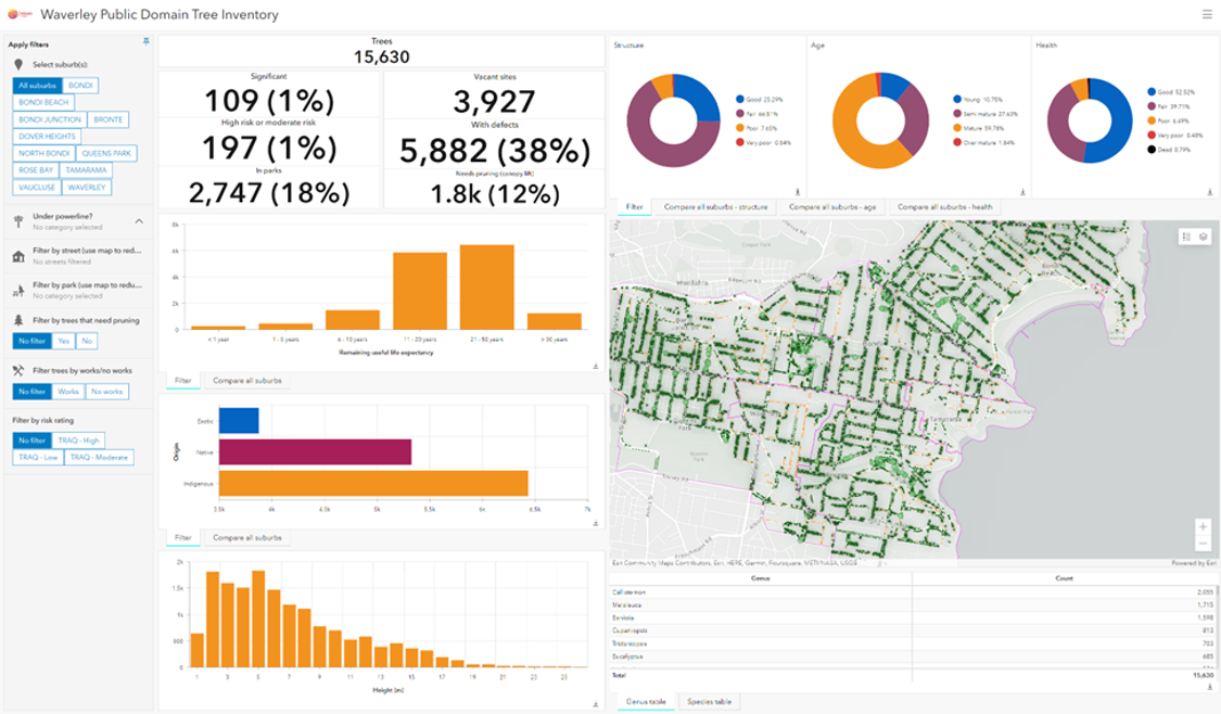
Jake Allen is a spatial data scientist and cartographer, known for blending technical expertise with creative vision to develop impactful, user-focused data products. With a passion for storytelling through maps and visualisation, Jake transforms complex datasets into intuitive, accessible tools that empower stakeholders to make informed decisions.<br>At Mosaic Insights, Jake has delivered a suite of innovative data products spanning dashboards, ArcGIS StoryMaps, scientific charts, interactive mapping applications, and clean, elegant cartographic outputs. His projects bridge cutting-edge analytics with clear, engaging communication, tailored to meet the unique needs of each client.<br><br>Jake has a particular interest in using spatial analysis to assess urban forests across Australia—how they are evolving, their vulnerabilities, and how this knowledge can guide strategic interventions. By integrating high-resolution satellite imagery, drone technology, machine learning, and advanced spatial techniques, Jake brings fresh insights to the pressing challenges of urban sustainability and resilience.<br><br>Jake’s strength lies in his ability to unite technical skills with storytelling and visualisation, creating data products that are both rigorous and accessible.

Dr Jabbar Khaledi
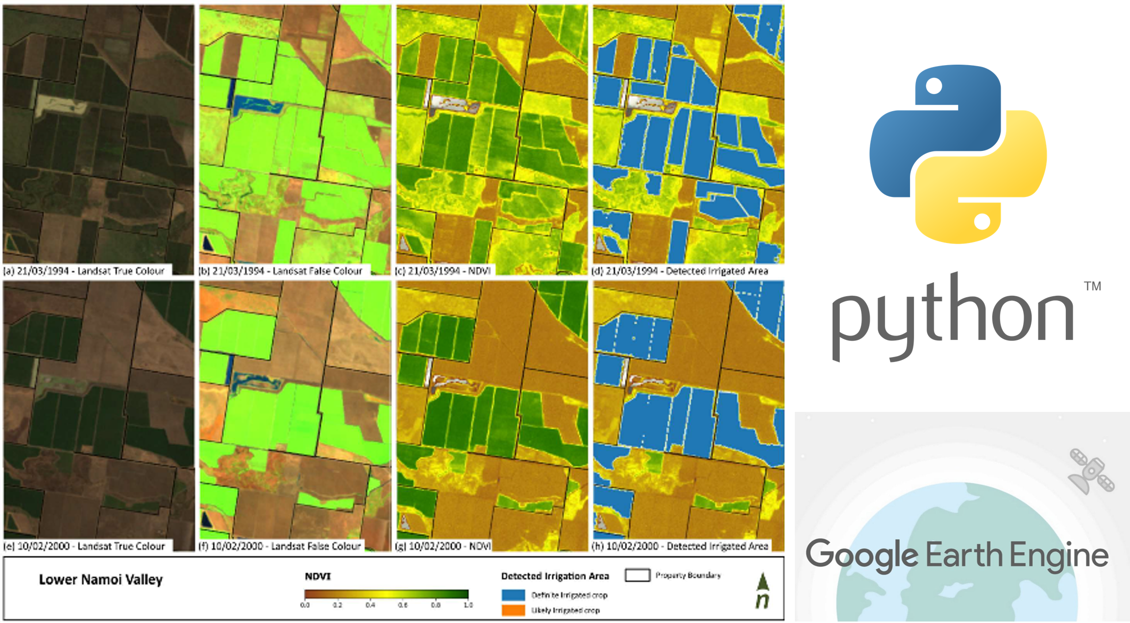
Jabbar Khaledi is an expert in hydro-climatology, earth observation, and environmental data analysis, with deep experience in analysing spatio-temporal data across climate, water, terrain, vegetation, and extreme events such as floods, bushfires, and droughts. He completed a PhD at the University of Melbourne (2018–2022) in hydro-climatology and water resources management, publishing peer-reviewed research on how catchment- and regional-scale water availability is influenced by climate change and variability modes (e.g., ENSO, IOD, SAM, IPO), droughts, and bushfires. Jabbar’s expertise lies in interpreting time series, remote sensing, and spatial datasets to understand complex climate–land–water interactions, and in developing environmental metrics, indices, and predictive models using machine learning and statistical techniques to monitor conditions and track changes over time.<br><br>Jabbar creates advanced models, tools, python packages, and automated workflows that support decision-making and provide practical solutions to environmental challenges across both catchments and urban areas. His technical skillset includes Python and its scientific libraries, ESRI GIS tools, REST API services, WCS clients, and cloud-based platforms such as Google Earth Engine (GEE), ESA, NASA MAAP, and ODC-DEA.<br><br>With a strong background in collaborative consulting, stakeholder engagement, and clear communication, Jabbar consistently delivers valuable insights and actionable outcomes tailored to client needs.